What is a Tree Survey, and When Do You Need One?

January 27, 2020
Posted 1/27/2020

Are you developing or building on land in a forested area or environmental corridor? Are you concerned about or required to identify trees that may have a disease? Do you want to map all of the trees on a piece of property that you own? If you answered yes to any of these questions, or have a different question about tree inventories or habitat restoration, we can help you.

What is a Tree Survey?

A tree survey is a process of identifying and measuring trees within a defined area and producing a detailed map with corresponding information about each tree in an attribute table. Tree surveys are often completed in both natural and urban streetscape settings and include identifying and recording the genus and species of each tree, measuring its Diameter at Breast Height (DBH), marking and numbering the tree with a tree tag or ribbon, and using a GPS to identify its specific location. A tree inventory map is then produced using the GPS data collected in the field. Site plans can be overlaid onto the map to determine how many individual trees and/or woodland acreage a project might impact. While most tree inventories are completed during the growing season, they can be completed during any time of the year. Tree identification is determined by leaf shape, leaf arrangement, bark, twigs, buds, leaf scars, fruits, flowers, overall tree shape, and even habitat. Our ecological team at raSmith has performed numerous tree surveys for our clients for a variety of reasons. The most common reasons that our clients need tree surveys for their projects include:

  • The project is located in a forested area and/or environmental corridor that is protected by a local unit of government.
  • The survey may be used to ascertain the health of individual trees and potential removal or maintenance needs.
  • Some ordinances specify that tree removals require a woodland restoration plan.
  • Tree measurements are required to determine if an area contains a “young woodland” or a “mature woodland,” due to different protection standards.
  • Tree identification is needed to determine the number of native tree species versus non-native species.
  • Trees with diseases such as Emerald Ash Borer must be identified as they pose a threat to safety in public areas.
  • The collection of baseline data is needed for woodland habitat restoration purposes.
  • A local unit of government wishes to create or maintain a database of trees in public areas or identify native “specimen” trees that they wish to protect.

Determine if Your Property Needs a Tree Survey

There are a number of reasons why a tree inventory may be necessary. This determination can best be made by a professional depending on the type of project and whether there are local ordinances with which you must comply. In many cases, a tree survey is necessary to bring your project into compliance with a municipal or county ordinance. For example, one of our clients, the City of Franklin, Wisconsin, has a Natural Resources Protection ordinance that requires the protection of both young and mature woodlands depending on their diameter.

Several reasons that you may be required to complete a tree inventory include the following:

  • Your project is located in a forested area and/or an environmental corridor that is protected by a local unit of government.
  • Some ordinances specify that tree removals require a woodland restoration plan.
  • Trees with diseases such as Emerald Ash Borer Disease must be identified, as they pose a threat to safety in public areas.
  • The collection of baseline data is needed for habitat restoration purposes.
  • You wish to inventory and map the trees on your property.

When You Should Plan Your Tree Survey

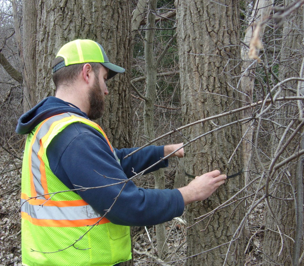
So, when is the best time of the year to complete a tree inventory, and how is the work completed? raSmith ecologists can complete a tree survey at any time of the year, as tree species are identified not only by their leaves, but also by their bark, twigs, and buds. We measure trees at breast height using a diameter tape and locate them using GPS technology or survey equipment. Maps are then produced for you, showing the size, location, and species of each tree within the project area.

Tree Survey Map

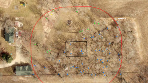
Portion of a tree survey map in a residential location.

If you are looking for financial assistance for your project, grant funding may be available for your project through various organizations such as the Wisconsin Department of Natural Resources (WDNR) Urban Forestry grant program, the U.S. Forest Service Landscape Scale Restoration Grants, and others.

Contact Us

If you need a tree inventory or know someone who does, please contact our ecologist, Thomas Johns, at tj.johns@rasmith.com or (262) 317-3228. We have completed numerous tree inventory projects for both the public and private sectors and can advise you on how to best handle your project and comply with local ordinance requirements, if applicable.

We can also evaluate the potential for your project to receive grant funding, make recommendations, and assist with grant writing.

Contact


TJ Johns provides ecological services with an emphasis on wetland delineation, tree surveys, GIS mapping, and other environmental project needs. For more information, contact us at (262) 317-3228 or email tj.johns@rasmith.com.

Related Services