 A potential client recently approached raSmith’s survey division for the completion of a hydrographic survey, also known as a bathymetric survey, for a 70-acre lake in southeastern Wisconsin. The individual was looking for an explanation of a hydrographic survey and a price estimate to complete the work.
As the director of survey services at raSmith, I often encounter these types of survey questions. I enjoy sharing my expertise related to how a particular type of survey is performed and the level of effort needed to accomplish the desired result. (Have a question? Ask now.)
What is Bathymetric Lake Surveying?
A bathymetric survey, also known as a hydrographic survey, is the process of gathering data from the bottom of water bodies such as lakes, ponds, rivers, and streams using an autonomous or manned watercraft. A multibeam echo sounder (or sonar system) is mounted on the watercraft to collect spot elevations on the bottom of the water body.
Reasons to Map and Survey a Lake
There are many different reasons why it might be necessary to map and survey a lake or other water body including water volumes, detention calculations, sediment levels, pond maintenance, dam rehabilitation, boat navigation, and scouring evidence.
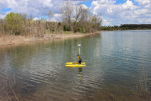
Different Ways to Conduct a Bathymetric Lake Survey
There are typically two ways to gather data for the bottom of a lake. One method is gathering data points with sonar, the other with a rod. Sonar can be collected by a remote control boat or a manned boat with an electric trolling motor. The process that uses sonar enables the surveyor to collect the most data in the least amount of time, thus reducing the cost per acre. However, this process is limited to water depths of two feet and greater, which means that some data must be collected with a survey rod along the shallow edges of the lake. The sonar collects data points (spot elevations) on the bottom of the lake at a surface of return. Vegetation, logs, rocks, debris, cars and anything else at the bottom of the lake will return a signal that is interpreted as the bottom of the lake and is not differentiated from the true lake bottom. Additional efforts are required to reach the true bottom.
A surveyor using the rod method can obtain sample sediment measurements in a smaller frequency and then map them. The key difference is that sonar mapping can be performed at a rate of approximately 10 to 15 acres per eight-hour day versus mapping the bottom of the lake by rod in the range of approximately five to eight acres per eight-hour day.
Lake Survey Cost Considerations
The cost of a lake survey is dependent on the needs of the client and the specifics of their project. Factors that directly impact the cost include the amount of information needed based on the purpose for the survey. Focusing on particular areas of concern such as potential dredge areas, as just one example, and minimizing data collection in areas where less data is needed are ways to minimize the cost of a lake survey.
Why raSmith?
raSmith has a long history of providing surveying services in the state of Wisconsin (since 1929). We take the time to thoroughly understand our clients’ needs and choose the most cost-effective method to successfully complete the project. Additionally, our advanced survey technologies such as hydrographic surveying are complemented by our growing team of water resources engineers. Their vast knowledge of the permitting process and lake management includes dredging, invasive species control, dam maintenance, and other related services.
About the Author

Eric Sturm is the director of survey services at raSmith. Eric has years of experience in a wide range of land development surveying projects. He is responsible for project research and setup, calculations, plan review, and quality control. Additionally, he manages multiple projects including coordination with design engineers, field crews and drafting technicians, and handling client communications while overseeing the survey services division.