News
UAS Services Are Among the Advanced Survey Technologies Offered at raSmith
raSmith’s Jon Chapman and Bill Wandschneider of the firm’s Brookfield, Wis. office have each obtained the newest certification available from the Federal Aviation Administration (FAA) for flying a UAS (unmanned aircraft system, also known as a drone) for commercial purposes. On August 29, 2016, the FAA authorized 14 CFR Part 107, which covers a broad spectrum of commercial uses for drones weighing less than 55 pounds, including the establishment of the Part 107 remote pilot certification.
raSmith has used UAS technology for a variety of project applications for both public and private sector clients, including topographic and planimetric mapping, volumetric surveying, orthorectified imagery and inspection imagery (building facades, utility towers, erosion monitoring and erosion control inspection), and others.
Advantages of using UAS technology include enhanced data collection on a wide range of projects; ability to better map areas that may otherwise be difficult or unsafe to traverse; and in certain instances, a more cost-effective means of collecting data versus traditional methods.
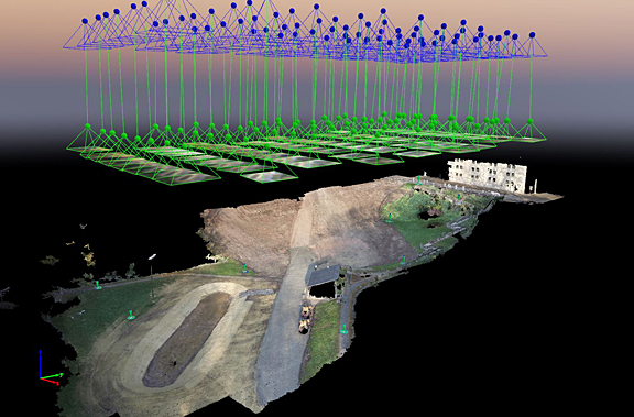
A UAS can be used to collect data and imagery that is processed using photogrammetric software to create 3D digital maps.
raSmith has been at the forefront of expertise in UAS technology having obtained a Section 333 Exemption and associated blanket COA (certificate of authorization) from the FAA in 2015. The firm originally began using the technology in 2015 for research and development. The survey division at raSmith was able to quickly move into offering UAS services based on the staff’s technical aptitude and their 14 years of experience in the use of advanced survey technologies that include LiDAR capture (also known as 3D laser scanning) and data extraction/3D modeling.
Richard Smith, president, is excited about the opportunities that advanced survey technologies have brought to raSmith and its clients. “At raSmith we are always looking for ways to save our clients time and money. The use of advanced survey technologies and the speed at which they are growing are phenomenal,” said Smith. “It’s exciting to see our staff using the latest technologies to more accurately and cost effectively collect survey data and overcome challenges that are plaguing our clients. While LiDAR capture as well as UAS services are becoming more mainstream in our industry, we believe that our staff excels not only in the use of these tools, but also in their real world application. We have been very successful in the integration of advanced survey technologies as extensions of our conventional surveying practices and only employ new solutions after they have been proven and vetted through sound research and development. We are excited about expanding our UAS services and will be making additional investments in this area in the near future.”