When on an airplane or viewing Google Earth, have you observed how roads create a grid pattern? Have you ever wondered why it is that way?
The simplest answer is because land surveyors in the early 1800s established the grid pattern. But there’s really a more interesting story behind why Wisconsin (and the Midwest) is square.
 For those of you old enough to remember, put yourself into the setting of the television show Little House on the Prairie that aired back in the 1970s and 1980s. Your family purchased 40 acres, built a cabin and began farming. As you finish plowing and planting your field, you look up and see your neighbor’s wagon and family walking across your just-plowed field on their way to town. You see, the original survey instructions did not address roads or traveling through the subdivided lands. Only after the Midwest was settled did the county or local government allow landowners to petition for the creation of a public road right of way. At that time it made sense to have each landowner contribute to the creation of the roads, so most were established along common property lines that just happen to be the grid patterns established by the first surveyors.
So the reason why the Midwest is so square is because the land was subdivided that way…AND the grid is the result of the 1800s road agreements to keep neighbors off each other’s land!
So how was it decided to create the grid pattern?
As a result of the Louisiana and other land purchases, the West was open to subdivision and settlement. At the 1785 Continental Congress, Thomas Jefferson is largely credited with the concept of “survey before settlement.” Several factors influenced the subdivision of the land:
- Immigrants were streaming into the country, creating a huge demand to settle in the West.
- The US Treasury had an urgent need for money.
- There was a need for surveyed boundaries to avoid conflicts with settlers and the government.
- Surveyed boundaries allowed the settlers to FIND the land (no realtors back then).
- Land prices were low, $1.25 an acre, which created a need for fast, efficient survey work.
- Surveyors earned from $4 to $10 per mile, split between a crew of five to eight men.
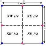
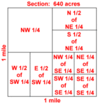 Quarter sections and a breakdown of quarter sections.
Original instructions for the division of land in the early 1800s called for the creation of townships. Townships were created by running lines with a magnetic compass every six miles: in a north–south direction (range lines) and east-west direction (town lines). Townships were created as a 36-square mile block, numbered from Section 1 to Section 36.
After the townships were surveyed, other surveyors were charged with creating and monumenting the interior 36 Sections, each one mile by one mile square. Monuments were set every 1/2 mile. This procedure established the framework of the four-quarter sections of each section.
Monuments were whatever was plentiful nearby. In Wisconsin, wood posts were set. In the Plains, an earth mound was created or stones were carried to the corner to create a pile of stones. It was expected as the land was passed from generation to generation, the owners would perpetuate the original monuments.
So now you know the whole story behind why Wisconsin (and the Midwest) is square and why land is subdivided the way it is!