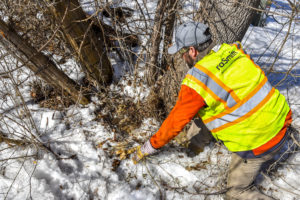
raSmith surveyors recover a unique survey monument.
While establishing horizontal and vertical survey control for a highway design project, the raSmith team recovered a unique survey monument near the roadside. The team cleared the leaves and snow, discovering a cross chiseled in a concrete monument — perpetuating the location of an original survey from the early-to-mid-1800s. In a way, it was like finding buried treasure (at least to a surveyor).
Historical “Landmarks”
Survey monuments such as this one are placed in the ground to indicate or reference section and quarter-section corners every half-mile, forming a grid system that serves as the basis for land ownership throughout much of the U.S. This grid is known as the Public Land Survey System (PLSS), which was originally conceived by Thomas Jefferson, a surveyor himself, in the 1780s. Vast tracts acquired after the Revolutionary War were at the disposal of the government. The U.S. wanted to reward soldiers for their service with land as well as sell land to raise much-needed funding to pay off war debt. A system to quantify, index and sell these extensive resources required surveying and survey monuments — lots of them.
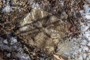
This survey monument features a chiseled cross symbol.
The rich history of land surveying has included various survey monuments that were specific to a given region and recognizable among peers. In the past, surveyors used common available resources as their monuments, such as wooden posts, stones and even wagon axles. Today’s survey monuments come in a wide array of materials and forms to suit a project’s needs — customizable aluminum, bronze and brass discs, steel rebar with plastic caps, and iron pipes, among others. Held to stringent standards, modern surveyors also have a supply of cutting-edge tools at their fingertips, such as survey-grade Global Navigation Satellite System (GNSS) technology and robotic total stations. There are even monuments with GNSS receivers constantly broadcasting positioning information available to surveyors and other users 24/7, including one at raSmith’s Brookfield, Wisconsin headquarters.
Even with high-tech tools, surveyors still benefit from and rely on early surveys established with corner monuments such as the one pictured above. They are used as starting points for today’s land measurements, and given the measuring tools available to original surveyors, their level of accuracy is quite remarkable! In the rules of boundary construction, original monuments are held paramount to everything else, including both recorded and current measurements.
Monumental Importance
Since the placement of original PLSS monuments across much of the U.S., survey markers continue to serve a variety of important purposes:
- Physically marking key points on the land’s surface
- Preserving the integrity of original property lines, right-of-way lines, and easement locations
- Representing legal boundaries of states, counties, cities, roads, and parcels of real property
- Preventing the potential for uncertainty and conflicts over boundaries
- Serving as the backbone reference framework for infrastructure, engineering, and construction projects
This list only scratches the surface — learn more about the overall importance of surveying here.
From stones to discs, survey markers are the focal points in land surveying, connecting the grid of measurements in the PLSS. The varied forms of monuments from past surveys share a part of history, reveal the methods of early surveyors, and make surveying even more interesting. What other monuments could await discovery?
How Can raSmith Help with Your Next Project?
Our professional surveyors use cutting-edge technology for land measurements and serve clients on a variety of projects. As one of the largest land survey and geospatial services firms in Wisconsin and the Midwest, we have extensive experience with providing remonumentation, boundary, topographic, and volumetric surveys; hydrographic surveys; LiDAR (3D laser scanning); unmanned aircraft systems (UAS); and other surveying services.