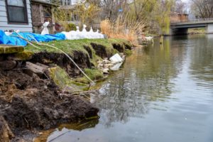
 On August 20 and 21, 2018, the City of Middleton’s Pheasant Branch Creek Watershed received between 11 and 13 inches of precipitation. This 1,000-year recurrence interval flood event caused extensive damage throughout the City, including damage to the Baskerville Harbor Bulkhead. The bulkhead is a steel sheet pile that supports the streambank near the outlet into Lake Mendota. Several homes were immediately adjacent to the damaged wall and scour in the channel threatened several critical utility crossings near Century Avenue Bridge.
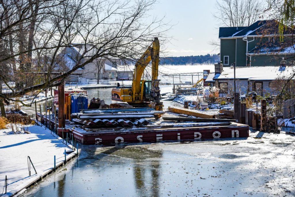
The City worked with raSmith to design the repairs to these critical infrastructure elements. A multi-disciplinary approach was required to address the surveying, hydrologic, hydraulic, structural and environmental design needs of the project.
Coordination between and across disciplines was essential for understanding the critical elements of the design. raSmith’s team frequently collaborates across disciplines to find the optimal solution, utilizing our collective knowledgebase.
LiDAR captures millions of points very rapidly, aids in shoreline rehabilitation design
Developing a plan to restore the Pheasant Branch Creek and Lake Mendota shoreline required a strong spatial understanding of the extensive flood damage. As with any data collection effort, it was important to identify what features to map and to what level of detail. Based on photos of the existing conditions, including chaotic areas of debris and shoreline erosion, it was obvious almost immediately to raSmith’s civil engineers that the identification of features to be mapped would not be an easy task.
Upon viewing the photos, our land surveying division determined it would be a significant challenge and a time-consuming effort to use a conventional surveying process (i.e., robotic total station and/or GPS). Under conventional methods, a surveyor captures one specific point at a time and provides a descriptive code for each point (i.e., edge of pavement, top of wall, etc.). During the processing of that data, survey office staff pull together the associated line work and other pertinent data and create a map that provides the information needed to design the shoreline improvements. At raSmith, we decided to take a more efficient route for this project given the ambiguity of what and how many features needed to be captured and to what level of detail. The scope and magnitude of this survey effort warranted the use of static LiDAR for the data capture.
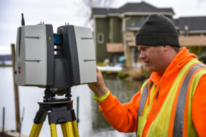 Unlike conventional survey methods, static LiDAR (or tripod-mounted 3D laser scanning) enabled our survey crews to capture millions of individual points in a matter of a few minutes. Setting up the scanner in a series of strategic locations (mainly driven by line-of-sight constraints) allowed our survey crew to blanket the shorelines with millions of points and create a LiDAR (point cloud) data set. The field crew set a series of survey control points, which were also captured during the scanning process, enabling the data set to be tied into the project control system.
Survey office staff compiled the point cloud data and published a Leica TruView data set that was easily shared and viewed by our civil engineers. Between the TruView imagery and some on-screen viewing of the point cloud data, our engineering and survey staff were able to collaboratively identify very specific areas of interest. Relevant points were subsequently extracted from the data set to map those features with an appropriate level of detail that would be most meaningful to the engineering effort.
Leica TruView is a web application that lets you easily view, pan, zoom, measure and markup point cloud data without needing to be an expert in laser scanning, CAD, or 3D. View the shoreline and flood damage with Leica TruView.
Contact Us
Our multi-disciplinary team is experienced with LiDAR services and is eager to assist you with your next project. If you have any questions, please contact senior project manager Jon Chapman at (262) 317-3366 (Brookfield, Wisconsin office).
LiDAR FAQ
Below are a couple of static LiDAR FAQs (frequently asked questions) that we often hear and our responses.
When is static LiDAR (3D laser scanning) a good option?
We like to employ static LiDAR data capture technology on projects where conventional data capture is not practical based on a number of different factors. These factors include considerations such as complex features (similar to this project in terms of storm-damaged infrastructure), detail needed on vertical features (such as a building or bluff faces), features that are difficult to access because of safety reasons (a busy intersection), and detailed spatial information inside of a building (architectural and/or structural features) or a manufacturing plant (mechanical, electrical and piping systems).
Does LiDAR (3D laser scanning) cost more than a conventional land survey?
Depending on the specific project, costs for LiDAR technology are often the same as conventional approaches. From a land surveying standpoint, raSmith approaches projects with a series of tools in our surveying tool belt (robotic total stations, GPS, static LiDAR scanners, UAV’s and hydrones). Our survey project managers are well versed in each of these tools and technologies and they understand the benefits and limitations of each. Multiple technology types are often employed on the same project in order to most efficiently capture the information needed, ensuring that our clients are getting the maximum value and return on their investment.